What's happening
Current activities across the project include ongoing haulage operations, which will continue day and night until mid-2026. Site preparation works are progressing, including clearing, mulching, topsoil removal and the placement of fill to support future construction. Retaining walls and drainage infrastructure are also being built across the project area, while utility works have commenced, including the relocation of telecommunications, overhead power and Water Corporation services.
Perth’s south-east corridor, home to fast-growing communities like Byford, Armadale, Kelmscott and Gosnells, is currently impacted by high volumes of heavy vehicles and through-traffic travelling to and from the South West and Wheatbelt regions.
The Tonkin Highway Extension and Thomas Road Upgrade will provide safer, more efficient travel for road users and heavy vehicles, reduce congestion, and improve connectivity between current and future residential, commercial, and employment areas.
These projects are being delivered together due to the timing of development and delivery, overlap of stakeholders and geographical location.
Tonkin Highway Extension
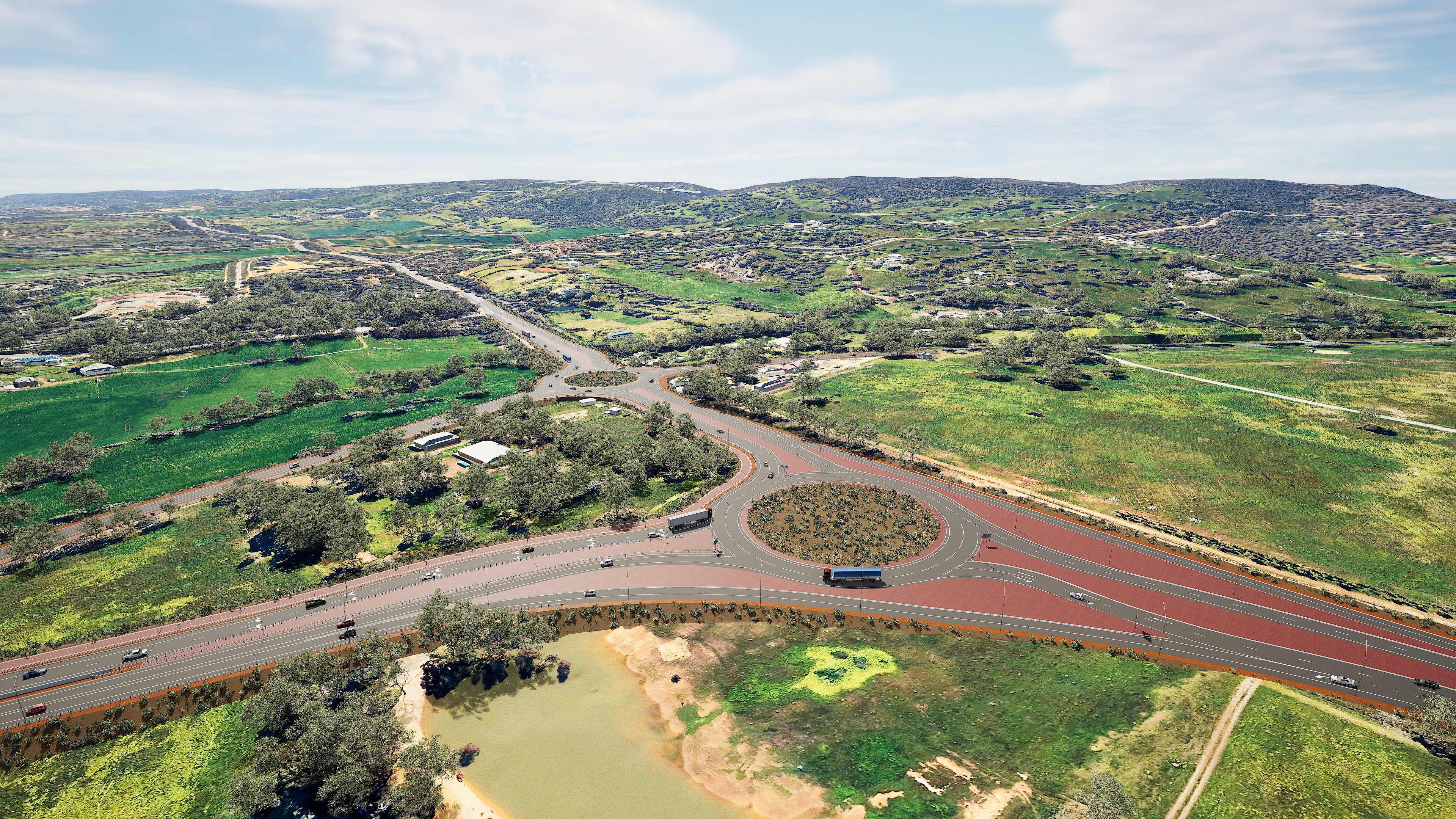
This project involves a new 14 km four-lane dual carriageway between Thomas Road and South Western Highway. It includes:
- Principal Shared Path (PSP) along the eastern side of the highway for the full 14 km, with connections to Thomas Road, Orton Road, Bishop Road, Mundijong Road and South Western Highway
- Five underpasses and a footbridge at Orton Road for safe crossing by pedestrians, cyclists
- Grade-separated interchange at Bishop Road to improve traffic flow and safety
- Roundabouts at Orton Road, Mundijong Road and South Western Highway
- Underpasses at Abernethy Road and Shanley Road to support vehicle, pedestrian, cyclist, and horse movements
- Underpass at Gossage Road to support pedestrian, cyclist and horse movements
- Rail bridges at Bishop Road and Wright Road
- Noise and visual screening walls, lighting throughout, and improved local road access including emergency egress
The project also caters for recreational needs by supporting the region’s equestrian network with several dedicated horse underpasses and connections.
Thomas Road Upgrade
This upgrade covers the duplication of 4.5 km of Thomas Road between Kargotich Road and South Western Highway, and includes:
- A new grade-separated interchange with Tonkin Highway to improve traffic flow
- A new 4.5 km shared path on the southern side
- A signalised equine crossing connecting Byford and Darling Downs bridle paths
- Intersection upgrades, including:
- New roundabouts at Kardan Boulevard and Masters Road/Malarkey Road
- Left-in/left-out access at Ballak Place and Briggs Road
- Cul-de-sacs at Hopkinson Road (north and south of Thomas Road)
- New traffic signals at Plaistowe Boulevard
- Reconstructed intersection at Wungong South Road
- Realignment of the equine path network north of Thomas Road to maintain connectivity
Temporary road closure
Shanley Road
From 12 January to late-2028
To safely construct the new Tonkin Highway Bridge over Shanley Road and to support the delivery of materials to site through the project haulage track, Shanley Road will be temporarily closed between Coogly Road and South Western Highway.
Please click on the map below for more information
Detour map for Shanley Road closure
Hopkinson Road
From 20 April to October 2026
To enable permanent construction to progress in the area, Hopkinson Road will be temporarily closed between Abernethy Road and Devon Court. Abernethy Road will remain open during these works.
Please click on the map below for more information.
Detour map for Hopkinson Road closure
Orton Road
From May to late-July 2026
To enable drainage and pavement construction for the new Orton Road and Tonkin Highway intersection, there is a proposed closure on Orton Road between Bullock Drive and Timbrel Road. For more information please follow the link below.
Please click on the map below for detours.
Detour map for Orton Road closure
Night works
Thomas Road
From 19 April to 30 April 2026, between 8pm and 5am
A lane closure is required to facilitate road widening works along Thomas Road between Masters Road and Plaistowe Boulevard. Stop/Slow traffic management will be in place. Following completion of works a traffic switch will be implemented.
Please click on the map below for more information
Traffic map for Thomas Road closure
Path and Bridle Trails
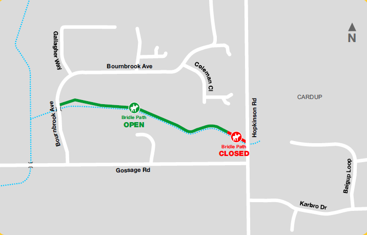
Bridle Path closure north of Gossage Road
From late October 2025
To enable construction of the new Tonkin Highway, a section of the existing bridle trail north of Gossage Road, between Bournbrook Avenue and Hopkinson Road will be closed from late-October 2025. A new bridle path connection will be provided via the Gossage Road underpass to Hopkinson Road by late 2028.
Please click on the link below for more information
Bridle Path closure north of Gossage Road
Speed limit reductions
Tonkin Highway
Ongoing to late-2028
Speed limit will be reduced to 60km/h on Tonkin Highway between Rowley Road and Thomas Road.
Thomas Road
Ongoing to late-2028
Speed limit will be reduced to 60 km/h in both directions on Thomas Road between Masters Road and Kargotich Road.
Mundijong Road
Ongoing to late-2028
Speed limit will be reduced to 60 km/h in both directions on Mundijong Road between Kargotich Road and Adonis Street.
South Western Highway
Ongoing to late-2028
Speed limit will be reduced to 60 km/h on South Western Highway between Watkins Road and Transit Road.
Wright Road
Ongoing to late-2028
Speed limit will be reduced to 40 km/h on Wright Road between Bilya Avenue and Watkins Road.
Kargotich Road
Ongoing to late-2028
Speed limit will be reduced to 60 km/h in key locations along Kargotich Road.
Community Information Sessions
We’d like to thank everyone who joined us at recent engagement events, including the SJ Farmers Market and our Community Information Session, where we connected with more than 240 local residents and stakeholders.
In addition, our team recently attended the Serpentine Jarrahdale Career & Enterprise Expo at Byford Secondary College. Across two days, we engaged with over 1,800 attendees, including students, parents, job seekers, and community members, promoting project awareness, job opportunities, and local career pathways.
Your valuable feedback and the insightful conversations were greatly appreciated. Further sessions will be scheduled in the coming months.
Ongoing engagement
We are working closely with the Shire of Serpentine Jarrahdale and have set up or attend the below working groups at this stage to understand local context and get feedback from key community members and stakeholders.
- Shire of Serpentine Jarrahdale Technical Working Group
- Environmental Working Group
- Equine Working Group
Delivering 14km of new highway and upgrading Thomas Road is a transformational investment in Perth’s south east. It will reduce congestion, improve safety and unlock access to freight routes and employment hubs – supporting METRONET, Westport, and the long-term growth of our WA.
But large-scale infrastructure must also be delivered responsibly.
That is why this project is underpinned by rigorous environmental planning, community engagement and sustainability principles, designed not just to reduce impacts, but to leave a positive legacy.
Responsible Vegetation Clearing and Rehabilitation
To deliver essential infrastructure, some vegetation clearing is required. We know this can raise community concern, and we want to be clear:
Clearing is being minimised wherever possible and carried out in strict accordance with environmental approvals.
The project has obtained approvals under the Environmental Protection Act 1986 and the Environment Protection and Biodiversity Conservation Act 1999, the clearing and construction is subject to the conditions of the approvals.
Key commitments include:
- Vegetation will only be cleared where absolutely necessary
- All unsealed disturbed areas will be rehabilitated and revegetated using a mix of engineered treatments and planting native species.
- Rehabilitation design is underway to maximise opportunities for restoration and biodiversity
Fauna crossings will be installed at waterways to maintain habitat connectivity.
Designing with the Environment in Mind
The project team is actively working to reduce the clearing of native vegetation by realigning roads, protecting trees near work zones where safe, adjusting locations of drainage basins and shared paths.
Flora, Fauna and Heritage Protection
We’ve engaged environmental specialists to assess, monitor and manage impacts on local ecosystems. This includes:
- Black Cockatoo habitat hollow inspections
- Qualified fauna handlers onsite during clearing to safely relocate fauna
We’re also progressing positive environmental initiatives:
- Collaborating with the Kaarakin Black Cockatoo Conservation Centre to provide cleared native vegetation (e.g. banksia cones, eucalyptus branches) to assist in Black Cockatoo rehabilitation.
- Grass tree salvage and replanting within the road corridor.
Protecting Aboriginal Heritage
Five Aboriginal Heritage sites are located within the project area. We have received approval under Section 18 of the Aboriginal Heritage Act 1972 to manage these areas respectfully, including salvaging significant items where required and engaging Traditional Owners to monitor ground disturbing activities.
Environmental Working Group
To ensure collaboration and transparency, the project team has established an Environmental Working Group (EWG) with stakeholders including the Shire of Serpentine Jarrahdale.
The EWG helps to:
- Share local environmental knowledge
- Provide feedback during project design and delivery
- Raise environmental concerns and community priorities
We thank all members for their contributions and look forward to continued collaboration.
Driving Sustainability and Innovation
The project is embracing sustainable construction by:
- Reusing surplus materials from other infrastructure works
- Prioritising the use of replacement and recycled materials where safe and suitable
- Reducing waste and conserving resources
Examples being explored include:
- Recycled road base, crushed concrete, brick and tile for sub-base and embankments
- Recovered sands and innovative materials
- Recycled plastic products for temporary works and furniture
All materials undergo laboratory and field testing in line with Main Roads and Australian Standards to ensure safety, quality and performance.
The project is predicted to deliver $15.2 million in annual vehicle operating cost savings, while reducing emissions through more efficient, and less stop-start travel.
The Tonkin Extension Alliance is currently undertaking market research to identify priority areas for material use and uncover new opportunities for sustainable sourcing.
If your organisation has innovative ideas, materials, or sustainability initiatives that could support this vision, we’d love to hear from you.
Project information
- Project Update - April 2026 - PDF (626 KB)
- Project Update - March 2026 - PDF (765 KB)
- Project Update - February 2026 - PDF (380 KB)
- Project Update - December 2025 - PDF (392 KB)
- Project Update - November 2025 - PDF (394 KB)
- Project Update - October 2025 - PDF (475 KB)
- Project Update - August 2025 - PDF (514 KB)
- Project Update - July 2025 - PDF (483 KB)
- Project Update - June 2025 - PDF (508 KB)
- Project Update - March 2025 - PDF (582 KB)
- Frequently Asked Questions - August 2024 - PDF (220 KB)
- Project Update - August 2024 - PDF (449 KB)
- Project Update - April 2024 - PDF (388 KB)
- Project Update - February 2024 - PDF (471 KB)
- Access and Connectivity Map - PDF (5.09 MB)
- Project Update - June 2023 - PDF (6.38 MB)
- Project Update - September 2022 - PDF (1.29 MB)
- Project Update - January 2021 - PDF (2.04 MB)
- Project Update - October 2020 - PDF (1 MB)
- Project Overview - June 2020 - PDF (2.38 MB)
Fact Sheets
- Environmental Management – June 2025 - PDF (492 KB)
- Managing Construction Impacts – June 2025 - PDF (376 KB)
- Managing Noise – June 2025 - PDF (529 KB)
Videos
- Drone lapse - Tonkin Highway / Thomas Road traffic switch - November 2025
- THETRU Story #1 - September 2025
Media Statements
- Joint Media Statement - Contract awarded for transformational Tonkin Highway project - 31 January 2025
- Joint Media Statement - Request for proposal issued for Package 2 Of Tonkin Highway Extension and Thomas Road Upgrade - 10 July 2024
- Tonkin Hwy Extension and Thomas Rd Upgrades continue progress - 22 March 2024
- Joint media statement - Expressions of interest called for Tonkin Highway Extension - 27 November 2023
- Industry workshop starts search for Tonkin Highway Extension contractor – 21 January 2021
- Roads budget delivers congestion busting solution and WA jobs - 9 May 2019
Funding
The $755 million project is jointly funded by the Federal ($604 million) and State ($151 million) Governments. $290 million is also allocated to upgrade Thomas Road, bringing the total funding commitment to $1.045 billion.
pressure on surrounding roads
travel times
road connectivity