Guidelines for Direction Signs in the Perth Metropolitan Area
Table of Contents
1. Scope and General
1.1 Scope
It is expected that road users will navigate by means of maps or street directories. Therefore, they need to be made aware and consistently reassured of the name of the route they are travelling on and to be directed to places prominently marked on maps even though these may not be their ultimate destination.
Australian Standard AS 1742.15-2007 Manual of Uniform Traffic Devices, Part 15: Direction Signs, Information Signs and Route Numbering was prepared by the Standards Australia Committee on Road Signs and Traffic Signals to provide uniformity in the use of direction signs and related navigational aids throughout Australia. In many instances, the standard is fairly general and provides each road authority some flexibility to specify their own requirements.
The purpose of these guidelines is to supplement AS 1742.15 by providing more detailed information on the types of direction signs and the selection of routes and destination names that are used by Main Roads in the Perth metropolitan area. For sign layout design details (legend type and height, arrows, route markers, vertical and horizontal spacing, etc.), refer to the Sign Face Layout Guidelines.
The guidelines generally conform with AS 1742.15. Where there is inconsistency between these guidelines and the AS 1742 series of documents, these guidelines shall take precedence.
1.2 Responsibility
Under the Road Traffic Code, Main Roads is responsible for the supply, erection and maintenance of traffic signs throughout the State. Although various agreements have been made to transfer the responsibility for some signs to Local Government, including street name signs, Main Roads has retained control of direction signs in the Perth metropolitan area to ensure uniformity and consistency of the system.
1.3 Route Numbering
Main Roads has chosen to retain the shield numbering system which is described in Australian Standard AS 1742.2-1994 Manual of Uniform Traffic Devices, Part 2: Traffic Control Devices for General Use. However, the shield based system has been replaced by an alphanumeric route numbering system of M, A, B and C Routes in AS 1742.15 and will no longer be supported in subsequent editions of AS 1742.2.
Where applicable, route markers shall be provided in the main sign panel of direction signs. Free-standing route markers shall only be used for advance or reassurance direction purposes where the corresponding direction signs have not been installed.
1.4 Related Documents
Australian Standard AS 1742.15 shall apply for all other signage not covered by these guidelines and the above related documents. AS 1742.2-2009 shall be used for the design and installation of route markers. |
2. Direction Signs at or Near Intersections
2.1 Advance Direction Signs
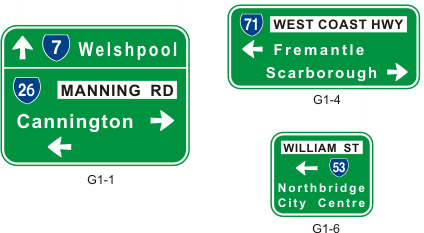
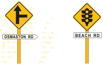
Advance direction signs should contain not more than five lines of legend. The name of the side road should be shown in black upper case letters on a white panel. At a cross route, a single road name is generally used for both directions. The through route is not normally shown unless it turns at an intersection or changes name.
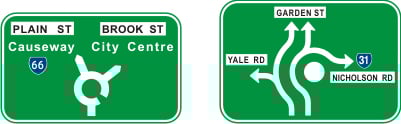
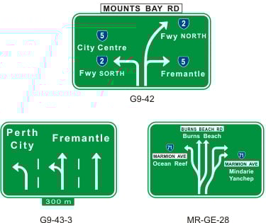
Stack and diagrammatic advance direction signs may be used. Stack signs are used at most intersections unless the intersection is a large roundabout or other complex intersection where a diagrammatic sign may be more descriptive. At multi-lane roundabouts where the lane allocations may be unusual or unexpected, a MR-GE-29 sign may be used in lieu of the standard G1-5 sign.
Distance plates below advance direction signs are not generally necessary except where there are intervening side roads or the sign is further in advance of the intersection than would normally be expected.
|
2.2 Driving Instruction Direction Signs
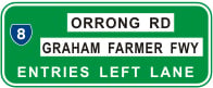
| Single lane direction | Mounted on the verge to advise motorists which lane to use for the indicated destination. |
| Overhead lane designation | Mounted on a bridge or gantry with the lane arrows directly above the lanes to which the destination applies. |
| Multiple direction |
Advises motorists of the lane configuration on the approach to the intersection. These signs are particularly useful where there are complex lane arrangements and trapped turning lanes. The G9-43-2 and G9-43-4 sign types shown in AS1742.15 are not used in WA. A MR-GE-28 sign showing the lane allocations should be used instead.
|
|
|
||
|
G9-8 Driving Instruction Direction Signs - Single Lane Direction |
||
|
|
||
|
G9-7 G9-7 Driving Instruction Direction Signs - Overhead Lane Designation |
Driving Instruction Direction Signs - Multiple Direction
2.3 Intersection Direction Signs and Fingerboards
Intersection direction signs and fingerboards are installed at intersections to supplement advance direction signs or on their own where advance direction signs are not warranted.
Intersection direction signs are generally chevron shaped signs where the turnoff is at right angles to the main route and rectangular shaped signs where the direction is at an angle or straight ahead and it is necessary to include an arrow.
The sign legend should not include more than two destination names in each direction. The route name is generally mounted as a separate panel on top of a chevron shaped intersection direction sign and within the main sign panel for a rectangular shaped sign.
Multiple intersection direction signs of the same shape may be installed on the same posts. Chevron shaped signs should have the same length along the straight section and should be mounted directly above each other. Rectangular shaped signs do not have to be the same length (although desirable) and are offset to emphasise the different directions.
Sight boards at the head of T-junctions may be omitted where intersection direction signs have been installed except in rural areas where approach speeds are high on the terminating leg of the intersection.
Intersection Direction Signs
Fingerboards are used at some minor intersections in place of intersection direction signs. Although fingerboards are not generally used in the Perth metropolitan area due their lack of conspicuity, they may be applicable in some semi-rural and rural environments.
Fingerboards may be single or double ended and contain a single location and distance for each point. A rectangular street name sign is generally mounted on top of the fingerboard sign.
Street Name Tag MR-GS-6
Fingerboards MR-GFB-1 (single end) and MR-GFB-2 (double end)
Fingerboard Sign Assembly
2.4 Reassurance Direction Signs
2.5 Advance Street Name Signs
An advance street name sign comprises a street name sign mounted below either a symbolic intersection warning sign for a priority controlled intersection or below a Signals Ahead W3-3 warning sign for a signalised intersection. They should be installed on the approaches to all intersections indicated in Table 5.3 except where advance direction signs including the street name have been installed or there is insufficient distance to install the signs between successive intersections.
W2-4 and MR-GS-3 Street Name Tag W3-3 and MR-GS-4 Street Name Tag
Advance Street Name Signs
An intersection warning sign used as an advance street name is not required to meet the normal warrant for an intersection warning sign described in Australian Standard AS 1742.2.
On the approach to a T-junction controlled by Give Way or Stop signs, a T-Junction sign (W2-3) is preferred to a Give Way Sign Ahead sign (W3-2) or a Stop Sign Ahead sign (W3-1) for use as an advance street name sign because it better describes the layout of the intersection. In situations where the visibility is restricted, W3-2 or W3-1 warning signs should be installed in addition to advance street name sign.
The position of advance street name signs shall be as indicated in Figure 2.1.
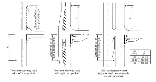
1: For crossroads the advance street name sign shall be positioned on both the left and right sides of a dual carriageway.
Figure 2.1: Position of Advance Street Name Signs
2.6 Typical Arrangement Diagrams
|
Typical locations of direction signs at various intersection types are shown in Figures 2.2 to 2.5.
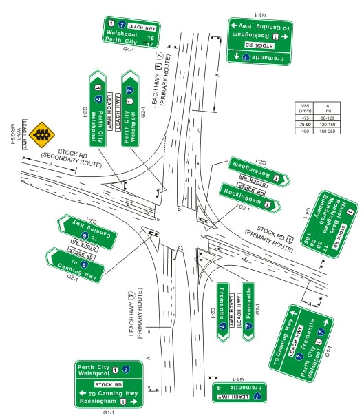
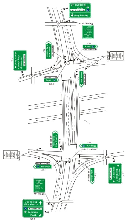
FIGURE 2.2: Major Urban Intersection of Two Primary Routes
FIGURE 2.3: Major Urban Intersection of a Primary with a Major Route
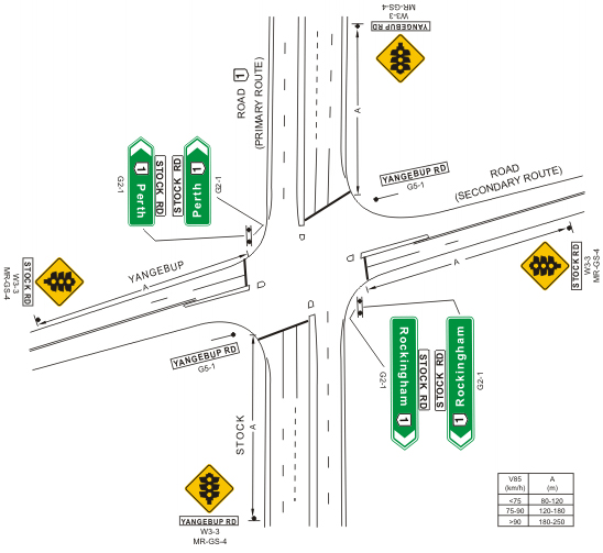
FIGURE 2.4: Minor Urban Intersection of a Primary with a Secondary Route
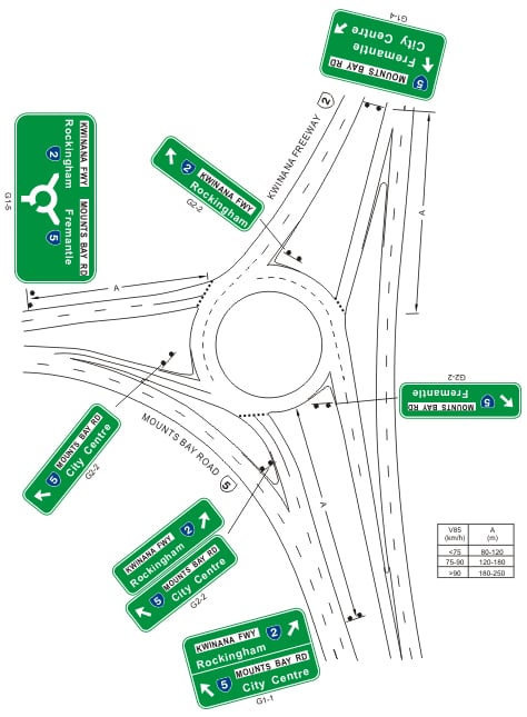
Note: The purpose of the diagram is to show both types of signs stack (G1-1, G1-4) and diagrammatic advance direction signs (G1-5). G1-5 signs are generally preferred on approaches to roundabouts. FIGURE 2.5: Major Urban Roundabout |

3. Freeway Direction Signs
3.1 General
Freeway direction signs are used on freeways, sections of expressways constructed to freeway standard and grade separated interchanges on other roads.
Road names are used to describe the exits from freeways together with destinations where the exit serves a suburb or major centre almost exclusively or where the destination has been included on reassurance direction signs along the freeway.
Distances on freeway direction signs are measured to the start of the taper of the off-ramp for the road being signed.
Lower case letters are used where the road name only is displayed on the sign. Where both the road name and the destination are included, the road name is displayed in black upper case letters on a white panel and the destination is in lower case.
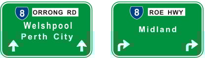
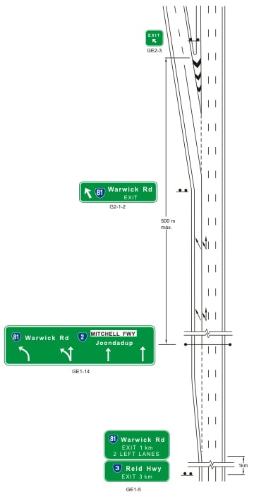
3.2 Advance Exit and Exit Direction Signs
Advance exit signs consist of two panels:
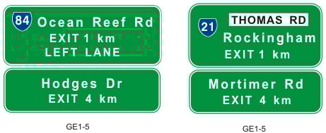
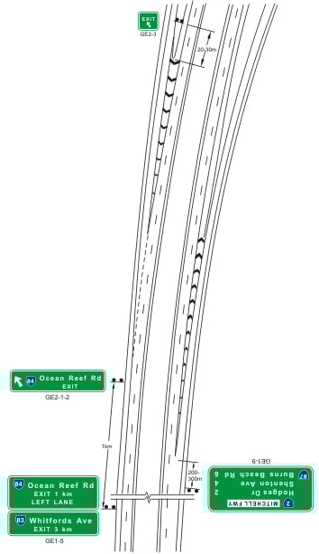
The top panel contains the road name and/or destination as well as the legend "EXIT 1 km" (or "EXIT 500 m" where exits are close together). The driving instruction "LEFT LANE" may also be included. For two-lane exits, the legend "2 LEFT LANES" may be used provided that the lanes referred to are fully developed or are about to be fully developed at the sign position. The top panel generally consists of three lines of text.
The bottom panel indicates the road name and/or destination of the following exit as well as the distance to the following exit.
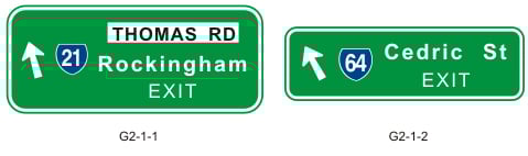
Exit direction signs shall be installed at, or as close as practical to, the start of the taper of the off-ramp.
Overhead signs mounted on bridges or gantries are often used at closely spaced interchanges or where clarification of the exit and through route is required. The signs contain upward pointing arrows below the destinations for lane designation purposes or beside the destinations where lane designation is not required. Downward pointing arrows are no longer to be installed.
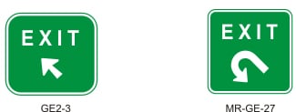
An exit gore sign (GE2-3) should be located in the off-ramp gore, 20 to 30 metres back from the nose. The size of the exit sign is the same for all road types. Where the existing ramp is a loop ramp, the modified exit gore sign MR-GE-27 should be used.
Exit Gore Signs |
3.3 Reassurance and Interchange Sequence Signs
Reassurance direction signs should be placed beyond each interchange with a Primary Route and at a spacing of not less than 10 km. Destinations shown on the signs are restricted to major regional centres.
Reassurance Direction Sign
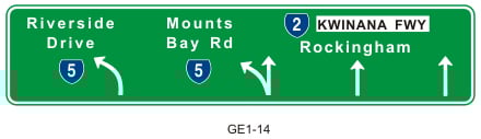
Interchange sequence signs are placed 200 to 300 metres beyond the on-ramp and provide confirmation of the route and the distance to the next exits along the route. Previously, these signs have been installed between the on-ramp and the off-ramp. The size of the route markers used for cross routes are reduced by one size to avoid a large space occurring between lines.
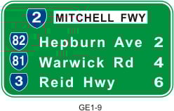
Interchanges Sequence Sign
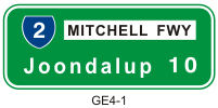
A variation of the interchange sequence sign is used on the approach to Perth City or a major regional centre served by more than one exit. The City Exits Interchanges Sequence sign contains the road names of the exits and enables the driver to select the most appropriate route to leave the freeway. This sign is placed prior to the advance exit signs for the first exit. "Perth City" or the name of the major regional centre is not repeated on the advance exit and exit direction signs.
City Exits Interchanges Sequence Sign
The distances shown on reassurance direction signs, interchange sequence signs and city exits interchange sequence signs shall be marked as follows:
- For distances less than one kilometre, the distance shall be given to the nearest 100m, shown in decimal format.
- For distances greater than one kilometre, the distance shall be given to the nearest whole kilometre
3.4 Direction Signs at Ramp Terminals
Advance and intersection direction signs at ramp terminals are generally treated in the same way as important non-freeway intersections. A minor variation is the use of a curved right turn arrow on the advance direction signs on the cross route to reduce the possibility of drivers turning onto the freeway off-ramp by mistake.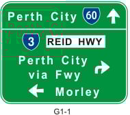
Advance Direction Sign on the Cross Route
3.5 Freeway Approach Signs
Direction to a freeway on-ramp may be indicated from an intersection using freeway approach signs. There are different freeway approach signs depending on the location of the intersection and whether the on-ramp serves one or both directions along the freeway.
Freeway Approach Signs
3.6 Road Access Signs
In terms of the Road Traffic Code 2000, certain classes of traffic are prohibited on a freeway or highway constructed to freeway standards. It is important therefore that road users are advised in advance of a freeway on-ramp whether they are prohibited from using the freeway. In Western Australia, sign MR-GE-25 (a modified version of GE6-2) should be installed in advance of any turn pocket leading to an on-ramp.
This is an information sign indicating the classes of traffic prohibited from using the freeway. Additional regulatory signs MR-RM-21 (a modified version of R6-13) shall be installed on the on-ramp as close as practicable to the ramp terminal. For two-lane on-ramps, these signs shall be installed on both sides of the road. It should be noted that the word "Freeway" on sign MR-GE-25 may be changed if the road is not commonly referred to as a freeway but is constructed to a freeway standard, eg. Roe Highway.
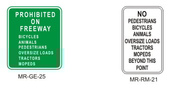
Traffic Prohibition Signs
3.7 Typical Direction Sign Treatments
|
Typical direction sign treatments at exits on freeways are shown in Figures 3.1 to 3.3.
FIGURE 3.1: Examples of Signs at a Single Lane Exit from a Freeway
FIGURE 3.2: Example of Signs at a Two-lane Exit from a Freeway
FIGURE 3.3: Example of Signs at Approaches to Ramp Terminals
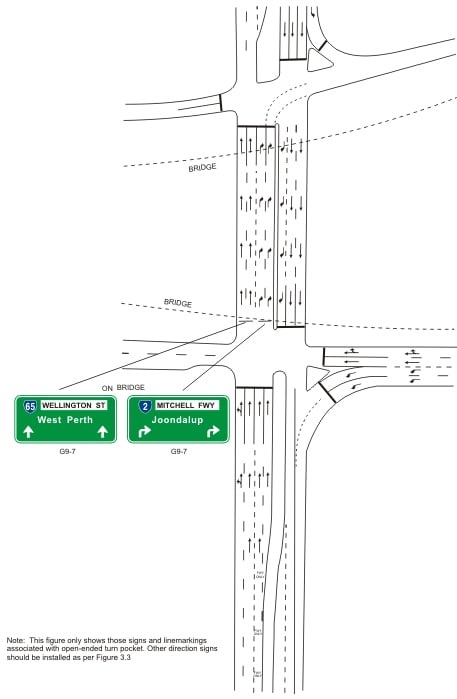
FIGURE 3.4: Example of Signs at Approaches to Ramp Terminals (Open-ended Right Turn Pocket) |
4. General Information Signs
4.1 Town Names
Town name signs are not generally used in the Perth metropolitan area where townsites are less defined but are applicable on the approaches to more remote townsites where the local government has not installed their own entry statements. The Main Roads version of sign G6-1 is shown below with white lettering on a green background and a border, as for direction signs.![]()
MR-GS-13
Town Name Sign
4.2 River and Bridge Names
River name signs may be used at the crossing of rivers, streams and creeks. A bridge name may be added below the river name or displayed on its own if the bridge is over a road or railway and has some local significance. These signs are similar to sign G6-2 but with a border to give greater prominence to the sign.
River and Bridge Name Signs
4.3 Kilometre Plates
Kilometre plates indicate the distance to the next place of importance on Highways and Main Roads. The plates are similar to G10-3 and comprise a plate mounted on a single post with white letters and numerals on a green background. The letters represent the name of a town or locality and the numerals indicate the distance. For example, A 50 - Albany 50 km or PH 180 - Port Hedland 180 km.
Kilometre plates are placed at intervals of 5 km in the more populated parts of the State and 10 km in pastoral areas. Kilometre plates should not be used on freeway-standard roads or within 25 km of the Perth City centre.
5. Direction Sign Schemes
5.1 Procedure for Preparation of Schemes
Various stages are involved in the preparation of direction sign schemes. A site visit is required at existing or modified road locations to identify any existing signs, determine exact sign locations and to design the posts and footings.
Stage 1 - Preparation of a Scheme Plan
- Prepare a background plan of the existing or proposed roads to be signed from road maps or construction drawings.
- Identify the classifications the roads to be signed - Refer to Section 5.2 and Appendix A.
- Show the destinations at all the intersections to contain direction signs - Refer to Section 5.2 and Appendix A.
Stage 2 - Identify Sign Types and Locations
- Determine the sign types for each intersection - Refer to Section 5.3.
- Indicate the sign types and their approximate locations on the scheme plan.
Stage 3 - Preparation of Individual Direction Sign Drawings
- Determine the letter sizes for each sign - Refer to Direction Sign Face Layout Guidelines.
- Prepare detailed drawings of the signs - Refer to Main Roads WA Direction Sign Face Layout Guidelines.
Stage 4 - Preparation of Location Plans
- Location Plans show the positions of the signs and may take one of two forms depending upon the size of the project.
- Larger projects:
- Signs shown on simplified construction plans, often referred to as "Large Signs Drawings" or "Major Signs Drawings".
- Smaller projects and isolated intersections:
- Sketch of the intersection layout with signs tabulated below the sketch.
- Determine the longitudinal locations of signs.
- Check that signs can fit in the verge and corner islands without being obscured or affecting the visibility of other signs and traffic signals.
Stage 5 - Design of Sign Posts
- Sign posts are designed in accordance with Main Roads Sign Structural Design Guidelines and tabulated on the individual direction sign drawings.
Appendix B contains examples of scheme plans and location plans used in the preparation of direction sign schemes.
5.2 Route Classifications and Destinations
It is not possible to put all the destinations on direction signs which motorists may want to use. The amount of information on advance and intersection direction signs should be the minimum necessary to provide adequate guidance. Additional information can be provided on reassurance direction signs. Too much information would result in complicated signs which would be difficult to read.
Perth Metropolitan Destinations Maps shown in Appendix A have been developed in order to provide consistency and continuity of directional information. Map 1 covers the northern metropolitan area and Map 2 the southern metropolitan area.
The route system shown on the Destinations Maps contains all National Highways and State Roads with some additional routes to important destinations. These routes provide a comprehensive coverage of the metropolitan area and link all major suburbs. Roads expected to be completed within the next few years are shown in dashed lines. Descriptions of the routes shown on the Destination Maps are given in Table 5.1.
|
Routes |
Definition |
| Primary Routes | National Highways and State Roads as indicated in the Destinations Maps (eg. Leach Highway, Canning Highway and Stirling Highway). |
| Major Routes | Other State Roads and some other routes to important destinations as indicated in the Destinations Maps (eg. Manning Road, Thomas Street and Warwick Road). |
| Secondary Routes | Secondary Roads as defined in the StreetSmart Street Directory other than Primary or Major Routes (eg. Vahland Avenue, Beach Road and Erindale Road). Street Directory other than Primary or Major Routes (eg. Vahland Avenue, Beach Road and Erindale Road). |
| Minor Routes | Minor Arterial Roads as defined in the StreetSmart Street Directory (eg. Beatrice Avenue, Angelo Street and Davallia Road). |
TABLE 5.1: Classifications of Routes for Direction Signs
Destinations named on the Destinations Maps are the only destinations that should be displayed on direction signs and should satisfy the following criteria:
| a) | They must be either major regional centres, well known suburbs or major industrial areas located at the terminations or intersections of important routes. |
| (b) | They must be located on Primary or Secondary Routes. |
| (c) | The name must be prominently displayed on road maps. |
The separation between destinations used for direction signs on Primary Routes is greater than on Major Routes because of their greater regional importance and the expectation that motorists using these routes will be travelling longer distances.
Generally, only one destination should be displayed for each direction at an intersection. This name will be the first destination after the arrow head on the route shown in the Destination Maps. The remaining destinations are intermediate destinations and are used on cross routes or on reassurance direction signs.
The exceptions where two destinations may be displayed on the advance and intersection direction signs are where:
| (a) |
The route does not lead directly to a major regional centre but the intersection is located close to a major cross road which is destined for that regional centre (eg. Welshpool and Rockingham along High Street from the intersection with Stirling Highway).
|
| (b) | The route is within the Perth metropolitan area and leads to a major regional centre before Perth (eg. Armadale and Perth along South Western Highway from the intersection with Thomas Road). |
| (c) | The route divides at a subsequent intersection into two routes of approximately equal importance (eg. Geraldton and Meekatharra along Great Northern Highway from the intersection with Roe Highway). |
A small arrow is sometimes used at an intersection on the Destination Maps where the continuity of a route for destination signing purposes is not apparent.
Terminology shown in Table 5.2 should be used for indicating Perth as a destination.
|
Destination |
Boundary Definition |
| Perth | Outside the area bounded by Reid Highway, Tonkin Highway, Roe Highway (including the MRS alignment to Stock Road), Stock Road, Leach Highway, Stirling Highway and Tydeman Road. |
| Perth City | Between and including the boundary definition for Perth and up to the boundary definition for Central Perth. |
|
Central Perth Destinations:
|
Along and within the area bounded by Newcastle Street, Graham Farmer Freeway, the Swan River, Kings Park Road and Thomas/Loftus Streets. |
TABLE 5.2: Perth Destinations
For city or town names other than Perth, the name followed by "City Centre" or "Town Centre" can be displayed from a Primary or Major Route that passes through or adjacent to the boundaries of the city or town.
The use of "To" followed by a route name may be used instead of a destination where a road terminates at a cross road instead of a destination, such as "To Albany Hwy". Also, "via" may be inserted between a place name and a route to indicate an alternative route, such as "Perth via Freeway". The letter type for "To" and "via" should match the letter type used in the sign legend.
The destinations "Fwy NORTH" and "Fwy SOUTH" may be used in lieu of the destinations shown in Maps 1 and 2 if the sign is installed within the Central Perth Area bounded by Newcastle Street, Graham Farmer Freeway, the Swan River, Kings Park Road and Thomas/Loftus Streets, as indicated by the green shaded area in Map 1.
5.3 Selection of Direction Signs
The types of direction signs placed at intersections depend on the significance of the intersecting routes.
Table 5.3 provides a guide to the selection of appropriate direction signs for at-grade intersections of various route types.
| Intersection | Direction Signs Treatment | |
| Route |
Direction Sign
|
|
| Primary/Primary | Both Routes |
Advance Direction Signs1 Intersection Direction Signs Reassurance Direction Signs |
| Primary/Major | Both Routes |
Advance Direction Signs1 |
| Major/Major | Both Routes |
Advance Street Name Signs Intersection Direction Signs |
| Primary/Secondary Major/Secondary |
Primary and Major Routes |
Advance Street Name Signs Intersection Direction Signs or Fingerboard Signs where there is a destination along the Secondary route |
| Secondary Route | Advance Street Name Signs | |
| Secondary/Secondary | Both Routes | Advance Street Name Signs |
| Primary/Minor Major/Minor Secondary/Minor |
Primary, Major and Secondary Routes |
Advance Street Name Sign |
| Minor Route | Nothing (unless the intersection is signalised2) | |
| Minor/Minor | Both Routes | Nothing (unless the intersection is signalised2) |
TABLE 5.3: Guide to the Selection of Direction Sign Treatments
Notes:
1. Driving Instruction Direction Signs may be required in addition to Advance Direction Signs.
2. Advance Street Name Signs are required at all signalised intersections unless Advance Direction Signs have been installed.
3. Street name signs are required at all intersections where Intersection Direction Signs containing street names have not been installed. The installation of street name signs is normally a Local Government responsibility but may be undertaken by Main Roads, particularly on new road projects where the installation of street names may be overlooked.
On freeways and other locations where the intersections are grade separated, freeway direction signs are required in addition to the above signs.
Appendix A
Perth Metropolitan Destination Maps
Appendix B
Examples of Direction Sign Schemes