


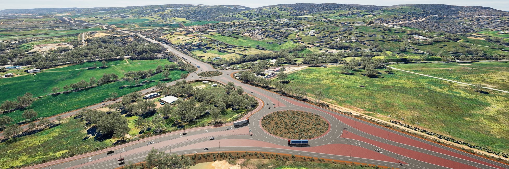
What's happening
To support ongoing construction through the wetter months, the project team has prioritised earthworks and drainage activities across the site to assist in managing weather related impacts.
These works included the placement of fill material to raise construction areas above the water-soaked areas and the construction of temporary and permanent drainage systems, helping to improve water management and site access.
While the project is well prepared for seasonal conditions, some activities remain weather dependent, such as concrete pours and asphalting, which can be affected by rainfall, moisture and temperature. During periods of heavy rainfall, the timing of certain activities may be adjusted to ensure the safety of both the community and workforce.
Current activities across the project area include:
- Clearing and ground preparation works.
- Bulk earthworks, including the placement, shaping, and compaction of materials.
- Construction of retaining walls and installation of drainage infrastructure, including rock pitching and culverts.
- Pavement construction works, including subgrade preparation and subbase placement.
- Utility works, including the installation of conduits and the relocation and protection of existing services.
Emergency Access Routes
As construction activities progress, there have been some minor changes to the temporary emergency access and evacuation routes in some areas surrounding the project area. We encourage residents in these areas to familiarise themselves with the updated routes below.
- Hopkinson Road south of Gloaming Way
- Jersey Road, Byford Meadows Drive and Timbrel Road north of Abernethy Road
- Gossage Road
- Lampiter Drive and Pure Steel Lane
- Shanley Road
During an emergency, evacuation warnings and directions are managed by emergency services. Residents should follow the latest information provided through Emergency WA alerts, the Emergency WA website and app, and directions from emergency services personnel on the ground.
Out of Hours Works
Thomas Road
From 4 November 2026 to mid-December 2026, between 7pm and 5am.
Intermittent out of hours works will occur on Thomas Road between Kardan Boulevard and Briggs Road. Activities include pavement construction, water blasting, line marking and barrier installations. Please follow traffic management in place.
Please click on the map below for more information
Temporary road closures
Shanley Road
Until late-2028
To safely construct the new Tonkin Highway Bridge over Shanley Road and to support the delivery of materials to site through the project haulage track, Shanley Road will be temporarily closed between Coogly Road and South Western Highway.
Please click on the map below for more information
Detour map for Shanley Road closure
Abernethy Road and Timbrel Road
19 October 2026 until mid-December 2026, with late-January 2027 as contingency
To minimise disruption for the community and to avoid the need for multiple road closures, the Project is working with the Shire of Serpentine Jarrahdale to coordinate works during a single closure of Abernethy Road, between Kargotich Road and Kardan Boulevard.
During this closure, the Shire will undertake road remediation works on Abernethy Road between Kargotich Road and west of Timbrel Road, while the Project will complete road connection works associated with the Abernethy Road realignment and new roundabout at Timbrel Road.
To safely complete these works, Abernethy Road will be temporarily closed between Kargotich Road and Kardan Boulevard from Monday 19 October 2026 to mid-December 2026, with late-January 2027 as contingency.
Timbrel Road will also be closed between Devon Court and north of Stockman Road during these works.
To help manage traffic movements, the following changes will be in place:
- Left turn only from Briggs Road onto Thomas Road.
- Traffic calming measures on Kargotich Road, including a temporary mini-roundabout at Orton Road.
During the closure of Abernethy Road, a proposed temporary closure of Timbrel Road north of Orton Road is anticipated from 20 November 2026 to approximately late-January 2027 to allow the construction of the Orton Road tie-ins to Timbrel Road. These works are important to maintain connectivity in the area during future stages of the Orton Road and Tonkin Highway intersection build
19 October to 19 November 2026
20 November 2026 to late-December 2026
Mundijong Road
Until December 2026
To enable permanent construction of the new Mundijong Road and Tonkin Highway intersection, Mundijong Road is proposed to be temporarily closed between Pure Steel Lane and Adonis Street.
The Lampiter Drive and Mundijong Road intersection will permanently close as part of these works, with emergency egress maintained at the end of Lampiter Drive.
Please click on the map below for detours.
Detour map for Mundijong Road closure
Plaistowe Boulevard - Subject to Approval
Enabling works - 23 October to mid December 2026
Full closure - early January 2027 to mid-April 2027
To enable construction of the Plaistowe Boulevard and Thomas Road intersection, Plaistowe Boulevard between Thomas Road and Caraway Avenue is proposed to be temporarily closed from early-January to mid-April 2027. The traffic signals at the upgraded intersection will be activated following the completion of the full Thomas Road duplication.
To minimise the duration of the full closure, staged single lane closures will occur on Plaistowe Boulevard from 23 October to mid-December 2026. This will allow enabling works to be completed, including excavation and installation of drainage infrastructure, prior to the full closure:
- Western lane closure of Plaistowe Boulevard between Caraway Avenue and Thomas Road (see detour map 1) from Friday 23 October 2026 until mid-November 2026; and
- Eastern lane closure of Plaistowe Boulevard between Thomas Road and Caraway Avenue (see detour map 2), mid-November 2026 to mid-December 2026.
23 October to mid November 2026
Mid November 2026 to mid December 2026
Early January 2027 to mid-April 2027
Path and Bridle Trails
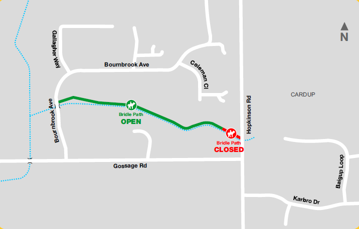
Bridle Path closure north of Gossage Road
Until late 2028
To enable construction of the new Tonkin Highway, a section of the existing bridle trail north of Gossage Road, between Bournbrook Avenue and Hopkinson Road. A new bridle path connection will be provided via the Gossage Road underpass to Hopkinson Road by late 2028.
Please click on the link below for more information
Bridle Path closure north of Gossage Road
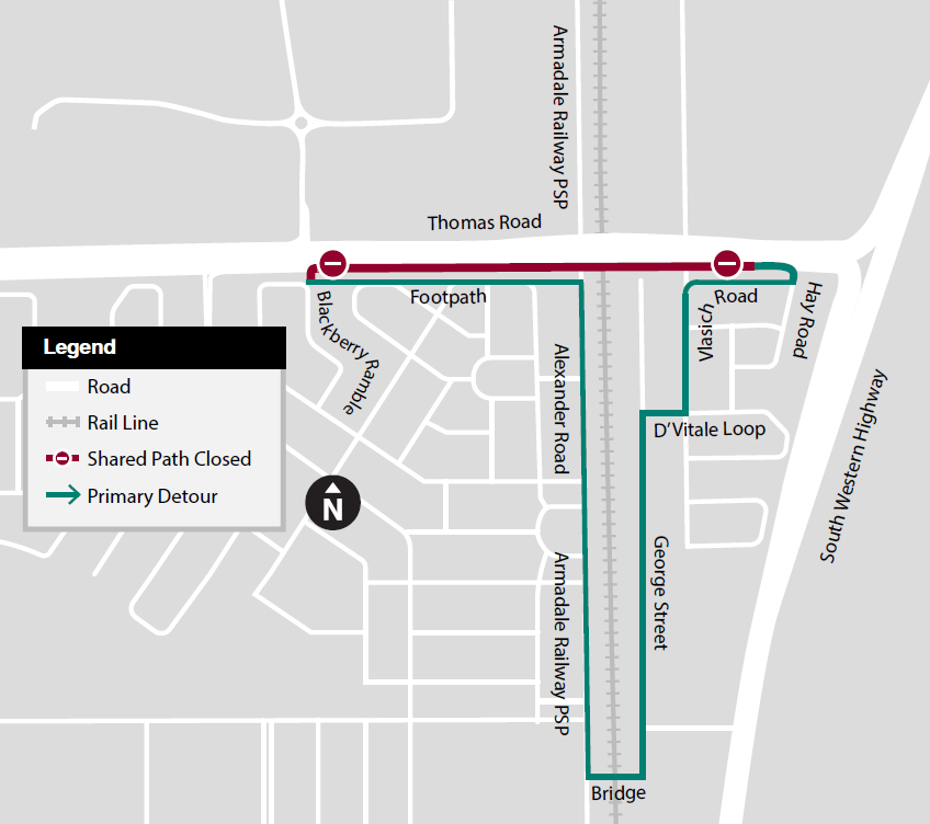
Shared Path - Thomas Road over Rail
Until May 2027
To enable realignment works, a section of the existing shared path, between Hay Road and Blackberry Ramble will be closed until May 2027.
Please click on the link below for more information
Shared Path - Thomas Road over Rail closure map
Principal Shared Path - Tonkin Highway
Until late 2028
To enable construction of the new Tonkin Highway and Thomas Road interchange, a section of the existing principal shared path, between Rowley Road and Thomas Road will be closed until late-2028.
Please click on the link below for more information
pressure on surrounding roads
travel times
road connectivity